I got a Report To Citizens from our County Manager yesterday. The eye candy, pictures of water on this arid land, jumped out, especially picture of the waterfall, the Grand Falls of the Little Colorado. It was only 40 miles from my house. It is ephemeral at best, sometimes huge, but rarely lasting longer than March into April. This had been a good snow year. It had been a decade since I’d been there. I resolved to go there again.
The next afternoon, a Sunday, I have driven the paved roads to the start of the 9 mile dirt leg, Navajo Road 40, ready for an adventure. Dirt roads are unpredictable. Depending on weather and maintenance priorities, rocks, washboards, sand, potholes, clay, and water traps can be features of them. Today the path starts wide and smooth, recently graded.
Plumes of fine dust pile up behind me. To the west I see dark cones of the San Francisco Volcanic Field. On both sides of the road are large expanses of dark earth, magma pebbles, cinders, and basalt outcrops, launched from the cones.
I soon reach the edge of a plain and drop down a steep hill. The land stretches into the distance, more cinders and basalt flowing down toward a valley created by the Little Colorado River. The river appears to marks a boundary where the black rock changes to the warm pastels of the Painted Desert.
Part way to the river, I pass through a single dust cloud, from a grader deployed to soften the the road challenges. (IR40 is a major thoroughfare for Navajo folks and an important emergency route in times of weather extremes, so the roadbed is a higher priority for road maintenance.) One only drives this land with such assistance.
The road continues to the river and then disappears, submerged, rut by rut, beneath a broad murky flow. I get out and stand next to the flow and cup my hands to capture some of it. It isn’t cold. Its colorado (“reddish”) sediment swirls and hides my hand. I remember seeing this river at its head, a clear flow starting high in the White Mountains, leaping over rocks and limbs before it drops onto the desert, gathering sediment as it flows through soft stretches, gathering white limestone, red sand, red mud, and milky clays into it, on its way to the crossing at my feet. It doesn’t leap. It lumbers as it heads towards the Falls, now “too thick to drink and too thin to plow” (Twain).
For a brief time, I am alone to contemplate this gift of water flowing in the desert. Soon an SUV appears on the far side of the river, plows through the water, and passes by me. Its door marks it as a non-emergency medical transport vehicle. Other visitors join me at the river. A lady drives up, walks toward me, and asks “where is chocolate falls?”. I point her toward her goal. Another car arrives, the driver wearing a Mt Whitney teeshirt. I once made an attempt to get to the 14,495 foot peak. He was snowed out once but has a permit to go back in 5 months. I wish him well.
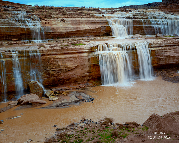
I drive around basalt piles to the Falls. There are several levels of viewing, from above the approach to the Falls to down at the landing zone below the Falls. My first stop is to view the approach. Standing near the river edge, I see it braided into channels with steps of little waterfalls, all part of the Falls. Debris, trees and eroded rock chunks, are distributed along the channels. I can also see beyond the final drop, down the river’s current canyon.
I’ve been down to the very bottom. This visit I stop at about the level of the big drop over the cliff. I can look back up the channels and see that the little falls I saw from above are joined by larger and larger ones until the final drop is reached. At the bottom, large boulders, pieces of the cliffs are washed by the falling water.
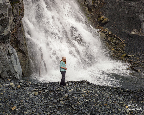
This isn’t my first waterfall. I’ve been up close and personal with several, in Utah, in the Sierras, in the Rockies, and in Alaska. They have both attractive and frightening, but always generous, sharing their driving sprays, their roars, theirs views, their energy, and their chilled cleansing.
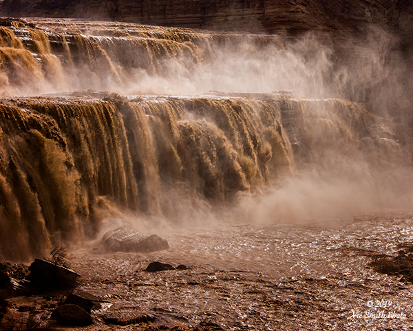
In total, Grand Falls is taller than Niagara Falls, for maybe two months in some years. When last I came here, ten years ago, the Falls were in full roar. Today, a month later in the season, they are thinner, but still captivating.
The roar of the Falls sends its spray to coat the ground about me and to wash over me, hitting my face, my sunglasses and the body of my camera, I can see and feel the murk from the colorado water, a grimy brown residue. I feel the energy of the water and its drop, but want to keep my camera optics covered and rinse off my exposed skin and glasses as soon as possible. As I walk, I am energized and also a bit coated.
The coating makes me wonder: how did this river, flowing through soft layers, create a tall waterfall? It had help. This is largely a land of sediments, layers rich in color. These layers are the roof, covers for molten layers swirling down deep. The sediments are the ancestors, dating back 200 million years. The lower layers are the new kids on the block, about 20 thousand years old.
During ancestor time the river sands carved a canyon along its path, like the big Colorado to the west. Then the new kids, cinders and basalt, rose. Cinders were sprayed about and basalt oozed out and started a dash down the hills toward the river. This probably looked then like what I saw recently in Hawaii, molten rock going wherever gravity drove it. The ooze reached the river, steamed into the existing canyon, and created a basalt dam that blocked the river. A lake formed. Eventually the river water found its way around the dam, to the north, over-topped it, and started a new canyon and today’s Grand Falls. Even today, where the power of the earth is concerned, stability is a convenient illusion.
AsI walk back to my truck I look at the people arrayed along the side of the Falls and the river. I came to see and to work, to capture, describe, and explain. From where did the other visitors come? How did they come to be here?
My thoughts go back a bit, to conversations with two friends, a devout Hopi and a devout Zuni. Their ancestors came by here not as visitors, but as parts of migrations, people in search of their promised homelands. The Little Colorado River (murk and all) was central to their people.
The Hopi story starts where the Little Colorado joins the Colorado, in the 3500 foot chasm carved by the Little Colorado. Near the junction is a unique site, a hill, the Sipapu, the place where the Hopi people believe their ancestors emerged into this, their 4th world. From this place these folks migrated far and wide, including along this river, on a quest to find the land that Creator had given them, the Hopi mesas. As some ancestors, members of the Tobacco Clan and the Coyote Clan, approached this land, they stopped at Homolovi, a now-protected site not far upriver from the Falls, built villages and planted crops along the river. These sites and this river are part of the sacred heritage of the Hopi people.
The Zuni people emerged further into the Grand Canyon and also migrated, their path taking them along the Little Colorado River toward their center place at Zuni. Its waters and soils sustained them on this journey. Zuni people regularly return to the river and its tributaries to gather sacred materials and to celebrate their heritage
For Hopi and for Zuni folks, this river is important to their lives. They were along the river a long time before me or my fellow visitors.
Now I ’m on my way home. I saw a picture, took a trip, found a gift, met travelers, and remembered friends. I am energized and humbled.
no images were found
**this piece is excerpted from a longer work intended for publication submittal
**please contact me (vic at vicsmithphoto.com) if you are interested in reviewing it
My thanks to Jessie for her help
V2 190505